By Greg Gerritt
June 29, 2017
Green Party of Rhode Island
We live in a world in which ecological destruction has run rampant, losing much of the habitat animals need for their survival, while at the same time destroying the ecosystems that billions of people depend upon for their daily bread. In my book the restoration of ecosystem health is the way forward for our communities as we sail into climate change under the dark clouds.
The Green Infrastructure Coalition, a partnership of approximately 40 organizations in RI and surrounding watersheds, is leading efforts in Rhode Island to help our communities use Nature Based Solutions to manage stormwater. Projects in Providence and surrounding communities, and on Aquidneck Island are being used to demonstrate the new technologies, and to encourage communities to adopt the techniques, as well as a regulatory framework to support this work. Friends of the Moshassuck has been a partner in this endeavor since the beginning, with a focus on ecosystems and wildlife rather than the human communities and city councils my colleagues are focused on Recently, after 5 years of study, on behalf of Friends of the Moshassuck and the City of Providence, I applied for a permit to make a minor modification to the rainwater pool in Providence’s North Burial Ground, so that it would continue to provide breeding habitat for Fowler’s Toads. High sediment loads are rapidly filling the pond so that it holds water for shorter periods of time and the rainwater pool is also being overrun by several plants that were not present 12 years ago. Both of these are threats to the viability of the pool as breeding habitat. The application is included with this essay, making up most of this post. For a bit of context I offer up one small video
This is the latest in the Rainwater Pool Series of videos I have made. All of the other Rainwater Pool Series videos as well as many videos of the wildlife in the rainwater pool are available on the Moshassuckcritters youtube channel.
In addition to restoring the habitat at this one pool, the project is a testing ground for some larger issues. The first is to demonstrate that as communities manage stormwater better, we should be aware that there might be places where it is appropriate to use of this newly managed and cleaner stormwater for the restoration of amphibian breeding habitat. Which leads to the need to change the stormwater regulations so that instead of demanding that all stormwater be infiltrated immediately, that there is an acceptance that in appropriate places, places to be determined by laying out a set of criteria and examining the fit, that stormwater can be used to create additional amphibian habitat.
I have not laid out the case for the more general rules in this application. But if we can make a convincing case for this site, it becomes a wedge we can use to begin the transforming of the rules. I would like to move much more quickly than I have to change the rules, but am content to do a thorough job demonstrating the ability to restore habitat properly and let the change in the rules follow.
My apologies that you are not able to see all of the exhibits and pictures that accompanied the application, but the videos on Moshassuckcritters will provide all of the visuals you will require to understand this application.

Application for a preliminary determination
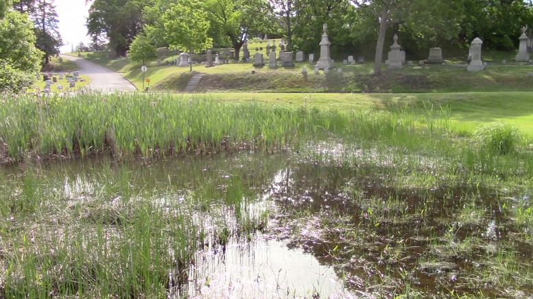
Friends of the Moshassuck in partnership with the City of Providence Parks Department, proposes to do a small deepening and restoration of the rainwater pool in the City of Providence’s North Burial Ground covered by the maps and photos in this submission. The rainwater pool is approximately 60 feet North –South and 100 feet East –West running from a road runoff chute (Exhibit A) in the northeast towards the southwest. It sits in a small bowl in the southwestern section of the Burial Ground immediately adjacent to the maintenance building. (Exhibits 1 and 2) The site was once near the Moshassuck River, but the site has been extensively manipulated over the years by the building of the Blackstone Canal and Interstate 95, and the original contours of the site are unknown. The river runs underneath the Interstate in this stretch. The site of the rainwater fed pool was for many years a small pond with a fountain, and it is possible the pond was constructed by digging out the bowl. Sometime after World War II, the City of Providence filled the pond so that the site could be used for burials, though no burials were made in the area, and the site still holds water for extended periods of the year. Currently the pool is completely dependent upon rainwater running off 3 roads in the cemetery and the pond levels go up and down pretty consistently with the rains. The semi natural wetland was noted in a 1976 report on the burial ground. The report stated that it was used to collect runoff, held amphibian breeding populations, and needed maintenance.
Friends of the Moshassuck’s watershed steward Greg Gerritt was first attracted to the pool in 2011 when he noticed black tadpoles one spring day. In 2013 the Moshassuckcritters video project of Friends of the Moshassuck started documenting the tadpoles and other NBG wildlife. As Greg spent more time at the pool and watched it change across the seasons and years, he came to understand the pool as a rainwater system, and studied how the Fowler’s Toads and Gray Tree Frogs interacted with the pool. ( Pictures of Fowlers toad and Fowlers Toad Tadpoles pictures 2A and 2 B)
The grass is mowed right to the edge of the wetland around most of the pool, with a steep sided section on the north covered in knotweed and vines. The pool is closely abutted on 2 sides (north and east) by cemetery roads. To the south and west the land rises to the cemetery sand piles and a dirt road providing access to the piles off the route to the main gate. Land management practices around the pond create some erosion, but the erosion of the dirt road, with its delta reaching on to the tarred road, is the source of most of the silt going into the pool, as silt deposits can be seen all the way from the delta to the pool. It seems like the pool has become shallower and vegetation has taken over more of the bottom of the pond recently. Pictures from 2004 and 2006 show no cattails and limited pickerelweed but currently cattails cover about 50% of the pool and they are spreading each year towards the west and south. Included in this submission are pictures that show the spread of the cattails. (Exhibits 3, 4 pictures from 2006 and 2004 Exhibits 5 and 6 2017 pictures of the rainwater pool and the recent expansion of cattails)
Recent studies suggest strongly that amphibian populations in New England are very dependent upon how long the hydroperiods are of ponds that do go dry and therefore have no fish. I believe that the shallowing of the rainwater pool is reducing its hydroperiod. Over the last few years the rainwater pool has gone dry with tadpoles in it, and then seen the toads and frogs try again when the rains returned. With a hydroperiod of between 12 and 14 days after 1.7” of rain, and the need to have about an inch of rain each week to maintain water levels, it seems that if the hydroperiod could be extended by 3 to 5 days for a full pond, that it might provide for a much higher percentage of years in which breeding is successful and little toads and tree frogs hop away from the rainwater pool during the summer. It is proposed that an area of about 900 square feet be deepened by approximately 8 inches in the center of the pool to increase the hydroperiod. (Exhibit 7 shows the dominant vegetation in the various parts of the rainwater pool. Exhibit 8 shows the depth in various areas of the pool. Exhibit 9 shows where the work will be done)
Amphibians
Amphibians, with the need for multiple habitats to complete their life cycles, are vulnerable, and even more vulnerable in civilization and during climate change. Amphibian populations and species are disappearing faster than any other large groups of species on the planet right now. The populations using the rainwater pool for breeding are the only Fowler’s Toad and Gray Tree Frog breeders noted in Providence for 100 years. A variety of other amphibian species live in the city, including a bullfrog population at a permanent pond in the Burial Ground, and it is likely that Tree Frogs occur in other parts of the city, but there is no evidence of additional Fowler’s Toad populations in the city, which is why this project is focusing on their needs.
Unlike some of the most vulnerable amphibians, Fowler’s Toads breed over a lengthy breeding season whenever conditions are right, and have further resilience in that they can have a breeding cycle interrupted by several dry weeks and start up again when the rains return. Gray Tree Frogs also breed at the pool over an extended season, but tree frog tadpoles are rarely seen, and in only one year in the last 5 have numerous shiny little green frogs come out of the pool. This year there were only 4 male tree frogs calling on the biggest night. The pool needs to hold water longer for tree frogs to metamorphose than the Fowler’s Toads as they mature a bit slower.
Long term observations of the Fowler’s Toads use of the pool suggests that they prefer an environment with limited vegetation. While they lay eggs on vegetation at the bottom of pools, the tadpoles are not strong swimmers and need open space for swimming. They do require vegetation for feeding (they eat algae and bacteria off the surface of the plants and other surfaces using a keratin scraper around the mouth) and the tadpoles seem to require shallow water unvegetated habitats for resting and sunning, the sunning appearing to be related to increasing body temperatures to increase the rates of digestion and growth. The tadpoles often reach greatest density in pond edge habitats, and their black color leads to the idea that they are intentionally soaking up sun in the way the turtles in the next pond do.
Fowlers Toads are later season breeders, not starting breeding until early May, and requiring evening temperatures to be 60 degrees Fahrenheit or warmer. It takes approximately 7 or 8 weeks from breeding until the tiny toadlets emerge from the water as hopping air breathers, meaning the pool must hold water continuously for two months for a successful breeding season in May, June, July, and into August
The watershed
Description of the Wetland
(Refer to exhibits A 1,2. 7,9 and pictures 10 to 13)
The wetland in question is about 100 ft long east west and about 60 ft north south. Water enters the pool from a chute in the northeast corner where the roads that drain the watershed all empty into the pool. The watershed that feeds rainwater to the pool is very small and is delimited on the largest scale map included in this submission. Water flows down the roads coming from the maintenance building parking lot, with most of the water draining to the north into the cemetery drainage system, but a sliver draining along the southern edge of the road entering the pool, from the southern edge of the road coming down the hill directly East of the pool, again with most of the water coming down the hill draining north towards the cemetery drainage system, and down the road draining the hills to the south and east. This last road is the contributor of the bulk of the water reaching the pool probably on the order of 80 to 90% of the water. All of the roads meet and at that intersection is a small semi engineered chute for the water to flow into the pool. The edge of the pool is 19 feet from the chute, with a flat grassed settling basin and an 8 inch high levee/filter of leaves and other vegetation settling out some of the silt. Silt also settles out amongst the cattails, the bulrush and other vegetation zones. In addition to draining the hillside roads, this road also carries water from the dirt road that provides access to the cemetery sand piles. Where the dirt road meets the tarred road there is a delta, a clear sign of how much silt is coming off the dirt road. Watching the rainwater run down the hill, the water running down the hill is a murky brown, which is an indicator of the sediment load.
The vegetation is patchy, with the northern part of the pool almost completely covered in cattails, cattails extending 67 feet from the northeast corner along the northern edge of the pool and 55 feet from the east towards the west in the center of the pool. The cattails were not present 12 years ago and are moving from east to west about 5 feet a year. The rest of the northern edge of the pool is covered in Soft stemmed bulrush. On the plat maps the blue or shaded area of the wetland extends further west in the north as if this was the part of greatest extension of the wetland. In reality at about 80 feet the western edge of the pond curves south, with the shaded areas only under water after the biggest rains, and the northwestern shaded area being vegetated by upland plants, primarily grasses. The mow line is well above the edge of the upland vegetation and dark stains on the grass show how high the water can get. The drop in water levels after a rain is very steady, and from the mow line in the southwest quadrant, which water reaches when the pool receives 1.7” of rain, the pool dries out in 12 to 14 days if there is no rain, regardless of temperatures, even draining out under the ice in winter. (Exhibit 9 and various pictures)
Hope Leeson of the RI Natural History Survey has provided a preliminary list of vegetation. The survey was done in early May, so some of the plants were hard to identify to species.
broad-leaved cattail, Typha latifolia
soft-stemmed bulrush, Schoenoplectus tabenaemontani
common woolgrass, Scirpus cyperinus
Japanese knotweed, Fallopia japonica
pickerelweed, Pontederia cordata
soft rush, Juncus effusus (ssp. cannot be determined until the formation of fertile stalks)
frost grape, Vitis vulpina (tentative)
climbing nightshade, Solanum dulcamara (tentative)
creeping bentgrass, Agrostis stolonifera (tentative)
lady’s-thumb smartweed, Persicaria maculosa (tentative)
+ a 2nd smartweed species – possibly Persicaria hydropiper
As noted above Cattails cover most of the pond, and there is photographic evidence that they extend their range 3 to 5 feet further west each year. Soft-stemmed Bulrush covers a fairly large section of the pool, with one patch running from the northwest shore(west of the cattails) along the curving western edge ending in a dense circular patch extending from 8 feet east of the mow line about 10 feet into the pool. The bulrush appears to be extending its coverage each year. On the map you can see that this is adjoining the Open water/pickerel weed section of the pool. In the past there was almost no vegetative cover in the center of the pol. The last unvegetated section is directly to the west of the cattails (picture 15 2016) near the northern edge of the pool about 60 feet from the eastern border, extending south along the cattail edge in a swath about 6 feet wide and curving back towards the east leaving a gap between the cattails and the southern shore Soft stemmed Bulrush, though the further extension of the cattails this year seems to have filled in this area. As shown in pictures from 12 years ago, the unvegetated area was much larger then, with the westward march of the cattails and the growth of the pickerelweed and bulrush resulting in nearly the entire of the pool now having a vegetated bottom. The unvegetated portion of the pool holds water the longest, but it is only 2 or 3 inches deeper than the rest of the area covered in pickerelweed. The last pools to hold water in the pool last year are depicted on Picture 10 and can be seen on Historical pictures 14 and 15 from 2016
The southern half of the pool has a more diverse vegetative cover. Soft-stemmed bulrush covers much of the area, extending about 55 feet along the southern edge and 20 feet north into the pool. At its northwestern edge it is about 15 feet from the circular patch that is the greatest extension south of the northern patch. Woolgrass is found among the southern patch of bulrush, with most of it found closer to the shore on “higher” ground, 2 inches or so above the more central spots. There is one rather odd small roundish patch of the spike sedge Eleocharis found in the southeast corner of the pool extending across the mow line. This patch of is only covered by water at the highest water, but both tadpoles and the little toads they become seem to like the area.
In many ways the rainwater pool is evolving the way wetlands do, it is filing in and the vegetation is building up the height of the ground, which in the normal course of evolution turns a wetland into dry land. The areas covered by cattails and bulrush are already being elevated by the building up of fallen vegetation and road silt and the build up is leading to the drying out of those areas sooner than previously. They have been elevated about 2 inches in the last few years. One can see this very clearly in the small sliver of water between the main section of cattails and the southern shore bulrush patch. The open water gets narrower each year, and has now been populated by cattails of ever increasing density.
The work
The work entails removing approximately 8 inches of silt from the deepest part of the pool, the part of the pool that holds water the longest, to create a “ Harbor of Refuge” and smoothly tapering off until at the current edge of the pool, or where we taper off in places that our work does not reach a shoreline, the depth remains the same as it is now. WE also propose to place a layer of bentonite clay at the bottom of the “harbor of refuge” area to slow infiltration. We shall cut the cattails back about 5 feet and create a small flat bottomed pool of last refuge approximately 20’ by 30’ in the places that now hold water the longest and in the course of removing a few inches of sediment as we slope upwards in the western part of the pond remove some of the pickerel weed, and marginally trim the Soft stemmed bulrush patches as we smooth out the slopes. The cattails, pickerel weed, and other plants should return on their own as none of their patches will be completely removed, though it is recommended that the cattail expansion through the pond be checked by cutting it back every few years or it will obliterate the pool. A map with current vegetation( exhibit 9) distribution is included with the submission as well as views of the proposed work. Pictures of the area from 10 years ago (exhibits 3,4) show a site with no cattails and no pickerelweed, conditions that were more prevalent 6 years ago when I started observing the pool than they are now.
No other vertebrates use the rainwater pool regularly, with ducks using it when it is very high and leaving as soon as it shrinks. Killdeer and sandpipers have been seen along the pool very occasionally in early spring, and Canada Geese use it at the highest water levels in the winter. A variety of insects use it as well as microscopic pond fauna. Doing the work in the off season (late August through December) and only when the pool has gone dry will prevent most harm to the fauna as well as flora. Honeybees kept up on the hill in the burial ground use the pickerel weed as a food source, but they too are done by the times of year we suggest is appropriate for this work.
The way the work would be done is with a crew of volunteers with shovels, with the silt removed returned to the city sand piles for use in the cemetery. We are not removing much soil, working approximately an area of 40 by 50 including tapering off areas and no more than 8 inches deep in the deep water refuge site in what is currently the deep part of the pool, and much less most places as it slopes to the current wetland edge.
About two inches of the top layer of pond bottom should be removed and kept separately. When done this should be returned to the pond to seed flora and fauna. This does mean that in the deep parts of the pool we shall dig down 12 instead of 8 inches so that we can add 2 inches of clay to the bottom before adding the 2 inches back. The clay layer is put on top of the bottom of the pond after excavation, rolled into the sediments, wetted, then covered with soil.
Friends of the Moshassuck is a regular partner with the City of Providence Parks Department on this and other sites in the watershed. The city is most willing to let FOTM do this project
It has also been suggested that some sort of silt filter be installed where the rainwater funnels into the pool basin in the northeast corner. That is a project for another year, and the current levee of leaves and brush do a pretty good job except at the highest levels of rainfall.
Addendum
When I spoke to the Restoration Team in February 2017 I made a tentative suggestion that a liner in the proposed deep hole would keep water in the system a bit longer. This was squashed for a variety of reasons, but as much as anything it was squashed because of a lack of understanding of the ecosystem under discussion by DEM personnel.
It is quite obvious to me that water is infiltrating into the ground, and as the water/water table goes down, the pond drains. Evidence for this includes the fact that the pond drains at practically the same rate all year round. The contrasting conditions of water draining under the frozen surface in the same number of days as the pond drains in the hot July sun causes me to conclude that infiltration, not evaporation, is why the pond goes dry on the schedule it does.
If that is true, that infiltration is critical, deepening the pool will enable the pool to hold water a few days longer, with the lowering of the water table needing to lower 8 more inches if the pool is to go dry. But it also continues to at least suggest that some sort of liner would help the pool to hold water even longer. It is proposed that the “liner” be in the form of a layer of Bentonite clay lain down at the bottom, and then covered by the two inches of upper sediments as has been discussed above.
The project is worth doing with or without a lining, But if DEM is going to continue to suggest no liner, I would like to see further explanation of why it is believed that evaporation rather than infiltration is the dominant mode of water lowering in the system at the consistent rates seen in all weathers including frozen.